
Mapa topográfico Saint John
Mapa interactivo
Haga clic en el mapa para ver la altitud.
Acerca de este mapa
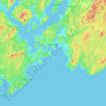
Nombre: Mapa topográfico Saint John, altitud, relieve.
Lugar: Saint John, Saint John County, New Brunswick, Canada (45.13325 -66.24562 45.37693 -65.83886)
Altitud media: 38 m
Altitud mínima: -7 m
Altitud máxima: 226 m
The topography surrounding Saint John is hilly; a result of the influence of two coastal mountain ranges which run along the Bay of Fundy – the St. Croix Highlands and the Caledonia Highlands. The soil throughout the region is extremely rocky with frequent granite outcrops. The coastal plain hosts numerous freshwater lakes in the eastern, western and northern parts of the city.
Otros mapas topográficos
Haga clic en un mapa para ver su topografía, su altitud y su relieve.
St. Martins
Canada > New Brunswick > Saint John County > St. Martins
St. Martins, Saint Martins Parish, Saint John County, New Brunswick, E5R 1C3, Canada
Altitud media: 30 m