
Mapa topográfico Numansdorp
Mapa interactivo
Haga clic en el mapa para ver la altitud.
Acerca de este mapa
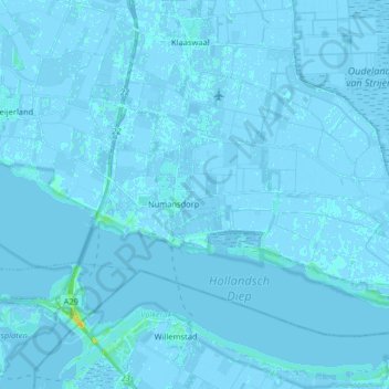
Nombre: Mapa topográfico Numansdorp, altitud, relieve.
Lugar: Numansdorp, Hoeksche Waard, Südholland, Niederlande (51.69247 4.37270 51.76531 4.53502)
Altitud media: 0 m
Altitud mínima: -4 m
Altitud máxima: 20 m
Otros mapas topográficos
Haga clic en un mapa para ver su topografía, su altitud y su relieve.
Hoeksche Waard
Niederlande > Südholland > Hoeksche Waard
Hoeksche Waard, Südholland, Niederlande
Altitud media: 0 m
Hoeksche Waard
Niederlande > Südholland > Hoeksche Waard
Hoeksche Waard, Südholland, Niederlande
Altitud media: 0 m
's-Gravendeel
Niederlande > Südholland > Hoeksche Waard
's-Gravendeel, Hoeksche Waard, Südholland, Niederlande
Altitud media: 0 m
Strijensas
Niederlande > Südholland > Hoeksche Waard
Strijensas, Hoeksche Waard, Südholland, Niederlande
Altitud media: 0 m
Klaaswaal
Niederlande > Südholland > Hoeksche Waard
Klaaswaal, Hoeksche Waard, Südholland, Niederlande
Altitud media: 0 m
Mijnsheerenland
Niederlande > Südholland > Hoeksche Waard
Mijnsheerenland, Hoeksche Waard, Südholland, Niederlande
Altitud media: 0 m
Strijen
Niederlande > Südholland > Hoeksche Waard
Strijen, Hoeksche Waard, Südholland, Niederlande
Altitud media: -1 m
Goudswaard
Niederlande > Südholland > Hoeksche Waard
Goudswaard, Hoeksche Waard, Südholland, Niederlande
Altitud media: 0 m