
Gracias por apoyar a este sitio ❤️
Haz una donación
Haz una donación
Mapa topográfico Baran
Haga clic en el mapa para ver la altitud.
Gracias por apoyar a este sitio ❤️
Haz una donación
Haz una donación
Baran
Baran is located at 25°06′N 76°31′E / 25.1°N 76.52°E / 25.1; 76.52. It has an average elevation of 262 metres (859 ft). It is surrounded by three Rivers Kalisindh, Parvati and Parban. The city is situated on the border of Rajasthan and Madhya Pradesh.
Gracias por apoyar a este sitio ❤️
Haz una donación
Haz una donación
Acerca de este mapa
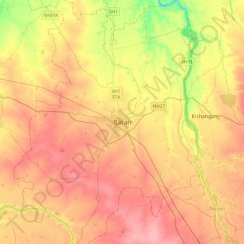
Nombre: Mapa topográfico Baran, altitud, relieve.
Lugar: Baran, Baran Tehsil, Baran District, Rajasthan, 325205, India (24.93819 76.35699 25.25819 76.67699)
Altitud media: 264 m
Altitud mínima: 212 m
Altitud máxima: 300 m
Gracias por apoyar a este sitio ❤️
Haz una donación
Haz una donación