
Mapa topográfico Herford-Stadt
Mapa interactivo
Haga clic en el mapa para ver la altitud.
Acerca de este mapa
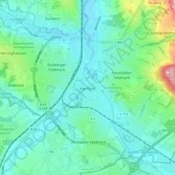
Nombre: Mapa topográfico Herford-Stadt, altitud, relieve.
Altitud media: 91 m
Altitud mínima: 59 m
Altitud máxima: 217 m
Otros mapas topográficos
Haga clic en un mapa para ver su topografía, su altitud y su relieve.
Hiddenhausen
Duitsland > Noordrijn-Westfalen > Kreis Herford
Hiddenhausen, Kreis Herford, Noordrijn-Westfalen, 32120, Duitsland
Altitud media: 92 m
Vlotho
Duitsland > Noordrijn-Westfalen > Kreis Herford
Vlotho, Kreis Herford, Noordrijn-Westfalen, 32602, Duitsland
Altitud media: 149 m
Kirchlengern
Duitsland > Noordrijn-Westfalen > Kreis Herford
Kirchlengern, Kreis Herford, Noordrijn-Westfalen, Duitsland
Altitud media: 80 m
Bonneberg
Duitsland > Noordrijn-Westfalen > Kreis Herford > Vlotho > Bonneberg
Bonneberg, Vlotho, Kreis Herford, Noordrijn-Westfalen, 32602, Duitsland
Altitud media: 150 m
Löhne
Duitsland > Noordrijn-Westfalen > Kreis Herford
Löhne, Kreis Herford, Noordrijn-Westfalen, 32584, Duitsland
Altitud media: 93 m
Vlotho
Duitsland > Noordrijn-Westfalen > Kreis Herford > Vlotho
Vlotho, Kreis Herford, Noordrijn-Westfalen, 32602, Duitsland
Altitud media: 119 m