
Mapa topográfico Lac Lacoste
Mapa interactivo
Haga clic en el mapa para ver la altitud.
Acerca de este mapa
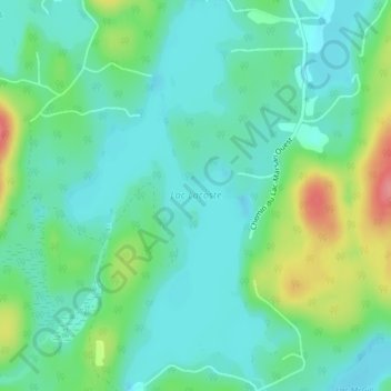
Nombre: Mapa topográfico Lac Lacoste, altitud, relieve.
Altitud media: 299 m
Altitud mínima: 275 m
Altitud máxima: 363 m
Otros mapas topográficos
Haga clic en un mapa para ver su topografía, su altitud y su relieve.
Lac Vert
Canada > Québec > Antoine-Labelle > Rivière-Rouge
Lac Vert, Rivière-Rouge, Antoine-Labelle, Laurentides, Québec, Canada
Altitud media: 348 m
Lac Malo
Canada > Québec > Antoine-Labelle > Rivière-Rouge
Lac Malo, Rivière-Rouge, Antoine-Labelle, Laurentides, Québec, Canada
Altitud media: 287 m
Marchand
Canada > Québec > Antoine-Labelle > Rivière-Rouge
Marchand, Rivière-Rouge, Antoine-Labelle, Laurentides, Québec, J0T 1T0, Canada
Altitud media: 269 m