
Mapa topográfico Panguitch
Mapa interactivo
Haga clic en el mapa para ver la altitud.
Acerca de este mapa
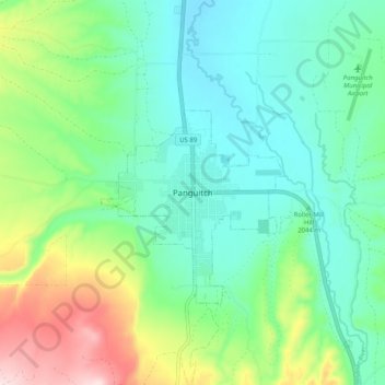
Nombre: Mapa topográfico Panguitch, altitud, relieve.
Lugar: Panguitch, Garfield County, Utah, 87459, United States (37.78276 -112.47576 37.86276 -112.39576)
Altitud media: 2.081 m
Altitud mínima: 1.987 m
Altitud máxima: 2.322 m
Panguitch was first settled in March 1864, when Jens Nielsen, a Danish convert to The Church of Jesus Christ of Latter-day Saints, led a group of 54 families eastward from Parowan and Beaver to the Sevier River. Due to the area's high elevation, 6,600 feet (2,000 m) above sea level, winter's cold weather arrived early in the year, and the most of the settlers' initial crops were killed by frost before they could mature. At a crisis point, seven men left the community to seek flour and foodstuffs from surrounding communities. Heavy snow forced the abandonment of wagons and teams, and the men finished their rescue mission on foot, reportedly by laying one quilt after another upon the snow to maintain their footing.