
Mapa topográfico Hilly Fields Local Nature Reserve
Mapa interactivo
Haga clic en el mapa para ver la altitud.
Acerca de este mapa
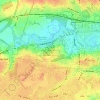
Nombre: Mapa topográfico Hilly Fields Local Nature Reserve, altitud, relieve.
Altitud media: 27 m
Altitud mínima: 4 m
Altitud máxima: 45 m
Otros mapas topográficos
Haga clic en un mapa para ver su topografía, su altitud y su relieve.
Fordham
United Kingdom > England > Essex > Colchester > Fordham
Fordham, Colchester, Essex, East of England, England, CO6 3NR, United Kingdom
Altitud media: 51 m
Wormingford
United Kingdom > England > Essex > Colchester
Wormingford, Colchester, Essex, East of England, England, United Kingdom
Altitud media: 44 m
Inworth
United Kingdom > England > Essex > Colchester > Inworth
Inworth, Colchester, Essex, East of England, England, CO5 9SP, United Kingdom
Altitud media: 46 m