
Gracias por apoyar a este sitio ❤️
Haz una donación
Haz una donación
Mapa topográfico Golbach
Haga clic en el mapa para ver la altitud.
Gracias por apoyar a este sitio ❤️
Haz una donación
Haz una donación
Golbach
Anstois | Benenberg | Diefenbach | Dottel | Frohnrath | Gillenberg | Golbach | Kall | Keldenich | Krekel | Rinnen | Roder | Rüth | Scheven | Sistig | Sötenich | Steinfeld | Steinfelderheistert | Straßbüsch | Urft | Wahlen | Wallenthal | Wallenthalerhöhe
Gracias por apoyar a este sitio ❤️
Haz una donación
Haz una donación
Acerca de este mapa
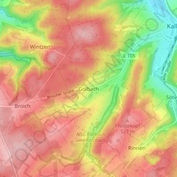
Nombre: Mapa topográfico Golbach, altitud, relieve.
Altitud media: 472 m
Altitud mínima: 367 m
Altitud máxima: 540 m
Gracias por apoyar a este sitio ❤️
Haz una donación
Haz una donación
Otros mapas topográficos
Haga clic en un mapa para ver su topografía, su altitud y su relieve.
Sistiger Heide
Deutschland > Nordrhein-Westfalen > Kreis Euskirchen > Kall > Benenberg
Altitud media: 570 m