
Mapa topográfico Rochehaut
Mapa interactivo
Haga clic en el mapa para ver la altitud.
Acerca de este mapa
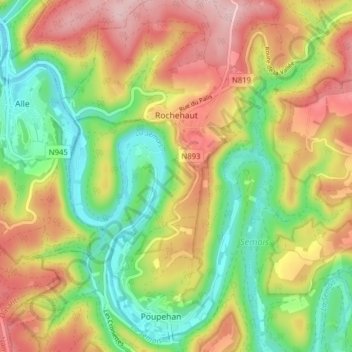
Nombre: Mapa topográfico Rochehaut, altitud, relieve.
Lugar: Rochehaut, Bouillon, Neufchâteau, Luxembourg, Wallonie, Belgique (49.80637 4.97086 49.85692 5.02732)
Altitud media: 296 m
Altitud mínima: 182 m
Altitud máxima: 431 m
Otros mapas topográficos
Haga clic en un mapa para ver su topografía, su altitud y su relieve.
Corbion
Belgique > Luxembourg > Neufchâteau > Bouillon
Corbion, Bouillon, Neufchâteau, Luxembourg, Wallonie, 6838, Belgique
Altitud media: 344 m
Le Tombeau du Géant
Belgique > Luxembourg > Neufchâteau > Bouillon > Ucimont > Botassart
Le Tombeau du Géant, Moulin du Rivage, Botassart, Ucimont, Bouillon, Neufchâteau, Luxembourg, Wallonie, 6833, Belgique
Altitud media: 300 m
Sensenruth
Belgique > Luxembourg > Neufchâteau > Bouillon
Sensenruth, Bouillon, Neufchâteau, Luxembourg, Wallonie, 6832, Belgique
Altitud media: 358 m
Bouillon
Belgique > Luxembourg > Neufchâteau > Bouillon
Bouillon, Neufchâteau, Luxembourg, Wallonie, 6830, Belgique
Altitud media: 338 m
Frahan
Belgique > Luxembourg > Neufchâteau > Bouillon > Rochehaut
Frahan, Rochehaut, Bouillon, Neufchâteau, Luxembourg, Wallonie, 6838, Belgique
Altitud media: 291 m
Dohan
Belgique > Luxembourg > Neufchâteau > Bouillon
Dohan, Bouillon, Neufchâteau, Luxembourg, Wallonie, Belgique
Altitud media: 284 m
Cordemois
Belgique > Luxembourg > Neufchâteau > Bouillon
Cordemois, Bouillon, Neufchâteau, Luxembourg, Wallonie, 6830, Belgique
Altitud media: 312 m
Curfoz
Belgique > Luxembourg > Neufchâteau > Bouillon
Curfoz, Bouillon, Neufchâteau, Luxembourg, Wallonie, 6831, Belgique
Altitud media: 344 m
Briahan
Belgique > Luxembourg > Neufchâteau > Bouillon
Briahan, Sensenruth, Bouillon, Neufchâteau, Luxembourg, Wallonie, 6832, Belgique
Altitud media: 363 m