
Mapa topográfico Buffalo National River
Mapa interactivo
Haga clic en el mapa para ver la altitud.
Acerca de este mapa
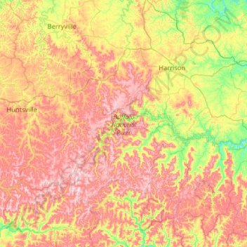
Nombre: Mapa topográfico Buffalo National River, altitud, relieve.
Altitud media: 444 m
Altitud mínima: 186 m
Altitud máxima: 775 m
Along the upper river, the gradient is steep and the water is fast, leveling and slowing as the river runs its course. The upper section has most of the whitewater rapids to be found along the river, and features dramatic karst topography including sink holes and caves, springs, and waterfalls, over 500-foot (150 m) tall sandstone and limestone bluffs, and many rock formations. At one point, a 0.65-mile (1.05 km) hike from the river up a narrow, boxed canyon leads to a 209-foot (64 m) waterfall, Hemmed-In-Hollow Falls, the highest of its kind between the Southern Appalachians and the Rockies. The river's current also gives life to well over 300 species of fish, insects, freshwater mussels, and aquatic plants.
Otros mapas topográficos
Haga clic en un mapa para ver su topografía, su altitud y su relieve.
Lead Hill
United States > Arkansas > Searcy County
Lead Hill, Searcy County, Arkansas, United States
Altitud media: 286 m
Saint Joe
United States > Arkansas > Searcy County
Saint Joe, Searcy County, Arkansas, 72675, United States
Altitud media: 260 m
Gilbert
United States > Arkansas > Searcy County
Gilbert, Searcy County, Arkansas, 72636, United States
Altitud media: 216 m
Buffalo River
United States > Arkansas > Searcy County > Gilbert
Buffalo River, Gilbert, Searcy County, Arkansas, 72636, United States
Altitud media: 217 m
Leslie
United States > Arkansas > Searcy County > Leslie > Leslie
Leslie, Searcy County, Arkansas, 72645, United States
Altitud media: 347 m
Cozahome
United States > Arkansas > Searcy County > Cozahome
Cozahome, Searcy County, Arkansas, United States
Altitud media: 307 m
Marshall
United States > Arkansas > Searcy County
Marshall, Searcy County, Arkansas, 72650, United States
Altitud media: 331 m