
Haz una donación
Mapa topográfico Dillberg
Haga clic en el mapa para ver la altitud.
Haz una donación
Acerca de este mapa
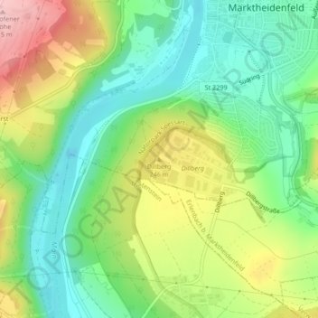
Nombre: Mapa topográfico Dillberg, altitud, relieve.
Altitud media: 203 m
Altitud mínima: 133 m
Altitud máxima: 314 m
Haz una donación
Otros mapas topográficos
Haga clic en un mapa para ver su topografía, su altitud y su relieve.
97828
Deutschland > Bayern > Landkreis Main-Spessart > Marktheidenfeld > Marienbrunn
Altitud media: 270 m
Altfeld
Deutschland > Bayern > Landkreis Main-Spessart > Marktheidenfeld
Der topographisch höchste Punkt der Gemarkung Altfeld befindet sich auf 371 m ü. NHN (Lage)49.835839.52862 am Birkenschlag, der niedrigste liegt etwa 350 Meter westsüdwestlich der Mündung des Klingelsbachgrabens auf 214 m ü. NHN (Lage)49.810639.58505.
Altitud media: 274 m
Haz una donación