
Mapa topográfico Ngong
Mapa interactivo
Haga clic en el mapa para ver la altitud.
Ngong
As of 2019, the population of Ngong Town consisting of Enchorro-Emunyi and Ngong Township locations is 25,866. The elevation of Ngong town is 1,961 meters in altitude, but the altitude of the hills is about 2,460 meters above sea level. Ngong was the central town of Ngong division while Kajiado County was a district.
Acerca de este mapa
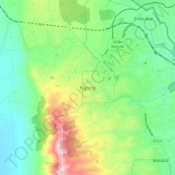
Nombre: Mapa topográfico Ngong, altitud, relieve.
Altitud media: 1.951 m
Altitud mínima: 1.733 m
Altitud máxima: 2.414 m