
Mapa topográfico Balut Island
Mapa interactivo
Haga clic en el mapa para ver la altitud.
Acerca de este mapa
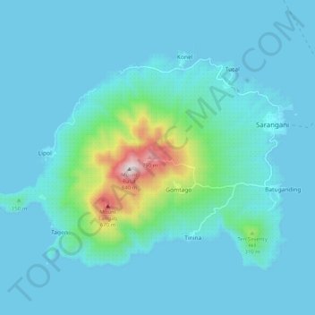
Nombre: Mapa topográfico Balut Island, altitud, relieve.
Altitud media: 87 m
Altitud mínima: 0 m
Altitud máxima: 827 m
Balut Island, the westernmost of the Sarangani Islands, is the larger, higher, and better cultivated than Sarangani Island. In the center of the island is Balut Volcano, which is fumarolic on occasion. Balut Island rises to about 1,800 metres (5,900 ft) from the seabed with the highest elevation at 862 metres (2,828 ft) above mean sea level. Base diameter of the island is 8 kilometres (5.0 mi).
Otros mapas topográficos
Haga clic en un mapa para ver su topografía, su altitud y su relieve.
Sarangani
Philippines > Davao Occidental > Sarangani
Sarangani, Davao Occidental, Davao Region, Philippines
Altitud media: 13 m