
Mapa topográfico Cabilao Island
Mapa interactivo
Haga clic en el mapa para ver la altitud.
Acerca de este mapa
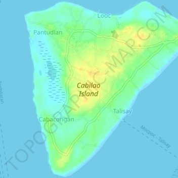
Nombre: Mapa topográfico Cabilao Island, altitud, relieve.
Altitud media: 6 m
Altitud mínima: -1 m
Altitud máxima: 24 m
Otros mapas topográficos
Haga clic en un mapa para ver su topografía, su altitud y su relieve.
Loboc River
Philippines > Bohol > Tagbilaran
Loboc River, Tagbilaran, Bohol, Central Visayas, Philippines
Altitud media: 199 m
Loboc River
Philippines > Bohol > Tagbilaran
Loboc River, Tagbilaran, Bohol, Central Visayas, 6316, Philippines
Altitud media: 28 m
Cancostino Island
Philippines > Bohol > Tagbilaran
Cancostino Island, Tagbilaran, Bohol, Central Visayas, 6329, Philippines
Altitud media: 89 m
Cabgan Islet
Philippines > Bohol > Tagbilaran
Cabgan Islet, Tagbilaran, Bohol, Central Visayas, 6329, Philippines
Altitud media: 90 m
Catang Island
Philippines > Bohol > Tagbilaran
Catang Island, Tagbilaran, Bohol, Central Visayas, Philippines
Altitud media: 79 m
Mantatao Island
Philippines > Bohol > Tagbilaran
Mantatao Island, Tagbilaran, Bohol, Central Visayas, Philippines
Altitud media: 0 m
Silo Island
Philippines > Bohol > Tagbilaran
Silo Island, Tagbilaran, Bohol, Central Visayas, 6330, Philippines
Altitud media: 90 m
Sandingan Island
Philippines > Bohol > Tagbilaran
Sandingan Island, Tagbilaran, Bohol, Central Visayas, Philippines
Altitud media: 10 m