
Mapa topográfico Budd Lake
Mapa interactivo
Haga clic en el mapa para ver la altitud.
Acerca de este mapa
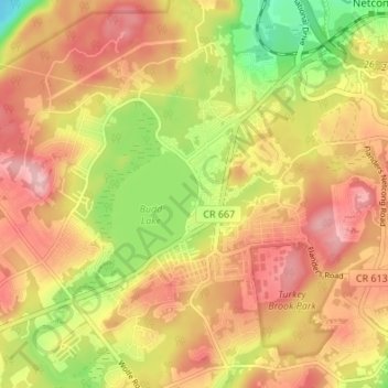
Nombre: Mapa topográfico Budd Lake, altitud, relieve.
Altitud media: 313 m
Altitud mínima: 223 m
Altitud máxima: 378 m
Budd Lake, which the community is named after, is the source of the South Branch Raritan River. A glacial lake at an elevation of 933 feet (284 m), Budd Lake has a surface area of 374 acres (1.51 km2). It is 7–12 feet deep, and can have large algal blooms. The bog, created by thousands of years of decaying plant material, supports wetland plants such as black spruce and tamarack, which grow on the floating mass. The lake is recharged through groundwater seepage through a series of wetlands, and serves as the headwaters of the Raritan River's South Branch. It is closely bordered by U.S. Route 46 to the south, and Sand Shore Road to the east.
Otros mapas topográficos
Haga clic en un mapa para ver su topografía, su altitud y su relieve.
Bartley
United States > New Jersey > Morris County > Mount Olive
Bartley, Mount Olive, Morris County, New Jersey, 07836, United States
Altitud media: 231 m
Flanders
United States > New Jersey > Morris County > Mount Olive
Flanders, Mount Olive, Morris County, New Jersey, 07836, United States
Altitud media: 255 m