
Mapa topográfico Marston
Mapa interactivo
Haga clic en el mapa para ver la altitud.
Acerca de este mapa
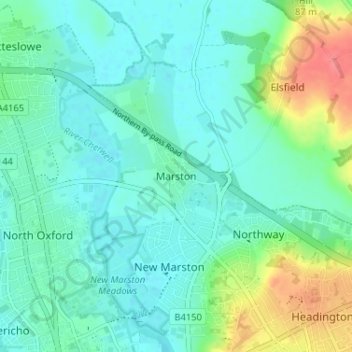
Nombre: Mapa topográfico Marston, altitud, relieve.
Lugar: Marston, Oxford, Oxfordshire, England, OX3 0PX, United Kingdom (51.75615 -1.25791 51.79615 -1.21791)
Altitud media: 71 m
Altitud mínima: 54 m
Altitud máxima: 122 m
Otros mapas topográficos
Haga clic en un mapa para ver su topografía, su altitud y su relieve.
Botley Stream
United Kingdom > England > Oxfordshire > Oxford
Botley Stream, New Botley, West Oxford, Oxford, Oxfordshire, England, OX2 0ED, United Kingdom
Altitud media: 67 m
Binsey
United Kingdom > England > Oxfordshire > Oxford
Binsey, Oxford, Oxfordshire, England, OX2 0NG, United Kingdom
Altitud media: 64 m
Oxford
United Kingdom > England > Oxfordshire > Oxford
Oxford, Oxfordshire, South East England, England, OX1 3HY, United Kingdom
Altitud media: 81 m
The Triangle
United Kingdom > England > Oxfordshire > Oxford
The Triangle, Iffley, Oxford, Oxfordshire, South East England, England, United Kingdom
Altitud media: 63 m
Littlemore
United Kingdom > England > Oxfordshire > Oxford
Littlemore, Oxford, Oxfordshire, England, United Kingdom
Altitud media: 67 m