
Mapa topográfico Mount Kinabalu
Mapa interactivo
Haga clic en el mapa para ver la altitud.
Acerca de este mapa
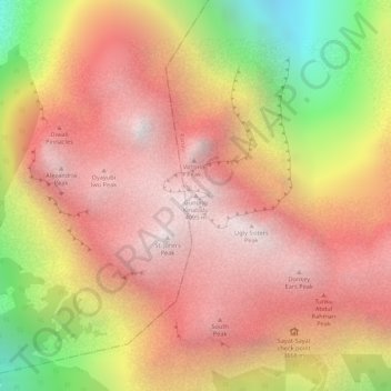
Nombre: Mapa topográfico Mount Kinabalu, altitud, relieve.
Lugar: Mount Kinabalu, Ranau, West Coast Division, Sabah, Malaysia (6.07502 116.55865 6.07512 116.55875)
Altitud media: 3.567 m
Altitud mínima: 2.661 m
Altitud máxima: 4.062 m
Mount Kinabalu (Malay: Gunung Kinabalu, Dusun: Gayo Ngaran or Nulu Nabalu) is the highest mountain in Borneo and Malaysia. With an elevation of 13,435 feet (4,095 m), it is third-highest peak of an island on Earth, and 20th most prominent mountain in the world by topographic prominence. The mountain is located in Ranau district, West Coast Division of Sabah, Malaysia. It is protected as Kinabalu Park, a World Heritage Site.
Otros mapas topográficos
Haga clic en un mapa para ver su topografía, su altitud y su relieve.
Sungai Liwagu
Malaysia > Sabah > Ranau > Kampung Kimolohing
Sungai Liwagu, Pekan Ranau, Kampung Kimolohing, Ranau, West Coast Division, Sabah, 89300, Malaysia
Altitud media: 633 m
Timbua B (Kombiroi)
Timbua B (Kombiroi), Ranau, West Coast Division, Sabah, Malaysia
Altitud media: 200 m
Togudon Lama
Togudon Lama, Ranau, West Coast Division, Sabah, 89308, Malaysia
Altitud media: 1.073 m
Kinabalu Park
Malaysia > Sabah > Ranau > Tinompok
Kinabalu Park, Tinompok, Ranau, West Coast Division, Sabah, Malaysia
Altitud media: 2.063 m