
Mapa topográfico Village of Mohawk
Mapa interactivo
Haga clic en el mapa para ver la altitud.
Acerca de este mapa
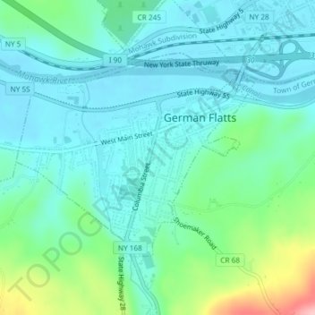
Nombre: Mapa topográfico Village of Mohawk, altitud, relieve.
Altitud media: 148 m
Altitud mínima: 114 m
Altitud máxima: 270 m
Otros mapas topográficos
Haga clic en un mapa para ver su topografía, su altitud y su relieve.
Dennison Corners
United States > New York > Herkimer County > Town of German Flatts
Dennison Corners, Town of German Flatts, Herkimer County, New York, 13407, United States
Altitud media: 404 m
Edicks
United States > New York > Herkimer County > Town of German Flatts
Edicks, Town of German Flatts, Herkimer County, New York, United States
Altitud media: 355 m
South Ilion
United States > New York > Herkimer County > Town of German Flatts
South Ilion, Town of German Flatts, Herkimer County, New York, United States
Altitud media: 239 m
Days Rock
United States > New York > Herkimer County > Town of German Flatts
Days Rock, Town of German Flatts, Herkimer County, New York, 13407, United States
Altitud media: 317 m
Fort Herkimer
United States > New York > Herkimer County > Town of German Flatts
Fort Herkimer, Town of German Flatts, Herkimer County, New York, 13350, United States
Altitud media: 177 m
Village of Ilion
United States > New York > Herkimer County > Town of German Flatts
Village of Ilion, Town of German Flatts, Herkimer County, New York, 13357, United States
Altitud media: 151 m