
Mapa topográfico Evrychou
Mapa interactivo
Haga clic en el mapa para ver la altitud.
Acerca de este mapa
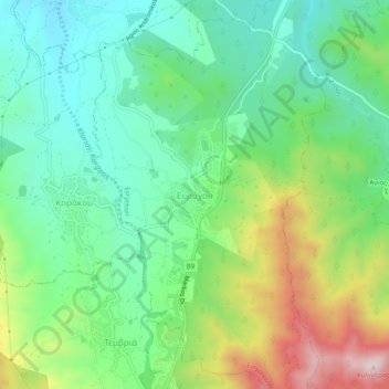
Nombre: Mapa topográfico Evrychou, altitud, relieve.
Lugar: Evrychou, Nicosia District, Cyprus (35.02120 32.88218 35.06120 32.92218)
Altitud media: 478 m
Altitud mínima: 300 m
Altitud máxima: 848 m
Evrychou is located in Nicosia District and it is the agricultural centre of the "Solea" region. It is located about 50 km south-west of Nicosia and 30 km from mount Troodos. The village is built at the east bank of the Karkotis (or Klarios) River, at an average altitude of 440 metres. The climate of the region is typically Mediterranean and so the cultivations found around the village vary from fruit-bearing trees (mainly apple, pear, plum, apricot, and peach trees) to citrus-trees, almond and olive trees. There are also cultivations of vines, vegetables and cereals.