
Mapa topográfico Mount Pleasant Township
Mapa interactivo
Haga clic en el mapa para ver la altitud.
Acerca de este mapa
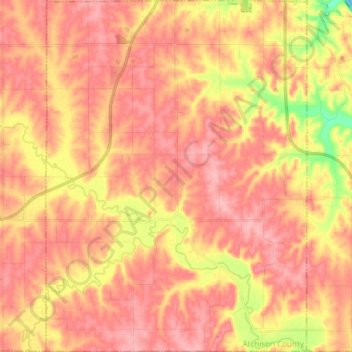
Nombre: Mapa topográfico Mount Pleasant Township, altitud, relieve.
Altitud media: 311 m
Altitud mínima: 235 m
Altitud máxima: 348 m
Otros mapas topográficos
Haga clic en un mapa para ver su topografía, su altitud y su relieve.
Huron
United States > Kansas > Atchison County
Huron, Atchison County, Kansas, United States
Altitud media: 349 m
Cummings
United States > Kansas > Atchison County
Cummings, Center Township, Atchison County, Kansas, 66016, United States
Altitud media: 316 m
Muscotah
United States > Kansas > Atchison County
Muscotah, Atchison County, Kansas, 66058, United States
Altitud media: 304 m
Effingham
United States > Kansas > Atchison County
Effingham, Atchison County, Kansas, United States
Altitud media: 340 m
Lancaster
United States > Kansas > Atchison County
Lancaster, Atchison County, Kansas, United States
Altitud media: 344 m
Shannon
United States > Kansas > Atchison County
Shannon, Lancaster Township, Atchison County, Kansas, United States
Altitud media: 330 m
Atchison
United States > Kansas > Atchison County
Atchison, Atchison County, Kansas, United States
Altitud media: 274 m