
Mapa topográfico Huailai County
Mapa interactivo
Haga clic en el mapa para ver la altitud.
Huailai County
Huailai County has a monsoon-influenced, continental semi-arid climate (Köppen BSk), with cold, dry, and windy winters and hot, humid summers, with temperatures slightly warmer than Zhangjiakou due to the more southerly location but still significantly cooler than in Beijing due to the high elevation. The monthly 24-hour average temperature ranges from −7.0 °C (19.4 °F) in January to 24.8 °C (76.6 °F) in July, and the annual mean is 10.01 °C (50.0 °F). A majority of the annual rainfall occurs in July and August alone. With monthly percent possible sunshine ranging from 60% in July to 73% in January and February, sunshine is abundant year-round, totalling about 3,030 hours annually.
Acerca de este mapa
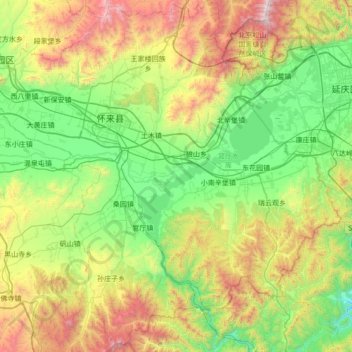
Nombre: Mapa topográfico Huailai County, altitud, relieve.
Lugar: Huailai County, Zhangjiakou, Hebei, China (40.06413 115.27853 40.58777 115.96294)
Altitud media: 840 m
Altitud mínima: 234 m
Altitud máxima: 2.218 m
Otros mapas topográficos
Haga clic en un mapa para ver su topografía, su altitud y su relieve.
Zhangjiakou
China > Hebei > Zhangjiakou
Lying in between the Mongolian Plateau and the North China Plain, Zhangjiakou has a somewhat rugged topography characterized by high mountains, deep valleys, and rocky pathways. As a result, it serves as a perfect natural screen for Beijing, which has made it a strategic priority militarily since ancient…
Altitud media: 959 m