
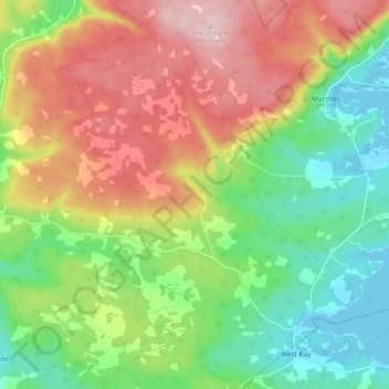
Mapa topográfico West Bay
Mapa interactivo
Haga clic en el mapa para ver la altitud.
Acerca de este mapa
Nombre: Mapa topográfico West Bay, altitud, relieve.
Altitud media: 109 m
Altitud mínima: -1 m
Altitud máxima: 251 m
Otros mapas topográficos
Haga clic en un mapa para ver su topografía, su altitud y su relieve.
Big Brook
Canada > Nova Scotia > Municipality of the County of Inverness
Big Brook, Municipality of the County of Inverness, Inverness County, Nova Scotia, Canada
Altitud media: 127 m
Mull River
Canada > Nova Scotia > Municipality of the County of Inverness > Mabou
Mull River, Mabou, Municipality of the County of Inverness, Inverness County, Nova Scotia, Canada
Altitud media: 83 m
Dunmore
Canada > Nova Scotia > Municipality of the County of Inverness
Dunmore, Municipality of the County of Inverness, Inverness County, Nova Scotia, Canada
Altitud media: 28 m
Point Cross
Canada > Nova Scotia > Municipality of the County of Inverness > Point Cross
Point Cross, Municipality of the County of Inverness, Inverness County, Nova Scotia, Canada
Altitud media: 97 m
Mabou
Canada > Nova Scotia > Municipality of the County of Inverness > Mabou
Mabou, Municipality of the County of Inverness, Inverness County, Nova Scotia, Canada
Altitud media: 81 m
Gillis Cove
Canada > Nova Scotia > Municipality of the County of Inverness
Gillis Cove, Municipality of the County of Inverness, Inverness County, Nova Scotia, Canada
Altitud media: 13 m
Kewstoke
Canada > Nova Scotia > Municipality of the County of Inverness
Kewstoke, Municipality of the County of Inverness, Inverness County, Nova Scotia, Canada
Altitud media: 161 m
Whycocomagh
Canada > Nova Scotia > Municipality of the County of Inverness
Whycocomagh, Municipality of the County of Inverness, Inverness County, Nova Scotia, B0E 3M0, Canada
Altitud media: 135 m
Pleasant Bay
Canada > Nova Scotia > Municipality of the County of Inverness
Pleasant Bay, Municipality of the County of Inverness, Inverness County, Nova Scotia, B0E 2P0, Canada
Altitud media: 80 m