
Mapa topográfico Nagaur
Mapa interactivo
Haga clic en el mapa para ver la altitud.
Acerca de este mapa
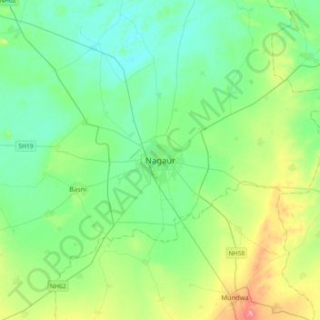
Nombre: Mapa topográfico Nagaur, altitud, relieve.
Altitud media: 303 m
Altitud mínima: 278 m
Altitud máxima: 376 m
Nagaur is located at 27°12′N 73°44′E / 27.2°N 73.73°E / 27.2; 73.73. It has an average elevation of 302 metres (990 feet). Nagaur is situated amidst seven districts namely Bikaner, Churu, Sikar, Jaipur, Ajmer, Pali, Jodhpur. Nagaur is the fifth largest district in Rajasthan with a vast terrain spreading over 17,718 km2 (6,841 sq mi) Its geographical spread is a good combine of plain, hills, sand mounds and as such it is a part of the great Indian Thar Desert.
Otros mapas topográficos
Haga clic en un mapa para ver su topografía, su altitud y su relieve.
Gogelao
India > Rajasthan > Nagaur Tehsil > Gogelao
Gogelao, Nagaur Tehsil, Nagaur, Rajasthan, India
Altitud media: 298 m