
Mapa topográfico Mount Etna
Mapa interactivo
Haga clic en el mapa para ver la altitud.
Mount Etna
During the first 1500 years CE, many eruptions went unrecorded (or records have been lost); among the more significant are: (1) an eruption in about 1030 CE near Monte Ilice on the lower southeast flank, which produced a lava flow that travelled about 10 km, reaching the sea north of Acireale; the villages of Santa Tecla and Stazzo are built on the broad delta built by this lava flow into the sea; (2) an eruption in about 1160 (or 1224), from a fissure at only 350–450 m (1,148–1,476 ft) elevation on the south-southeast flank near the village of Mascalucia, whose lava flow reached the sea just to the north of Catania, in the area now occupied by the portion of the city named Ognina.
Acerca de este mapa
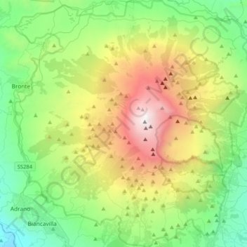
Nombre: Mapa topográfico Mount Etna, altitud, relieve.
Lugar: Mount Etna, Catania, Sicily, Italy (37.62235 14.82551 37.87524 15.13241)
Altitud media: 1.157 m
Altitud mínima: 144 m
Altitud máxima: 3.312 m
Otros mapas topográficos
Haga clic en un mapa para ver su topografía, su altitud y su relieve.
Mount Etna
During the first 1500 years AD, many eruptions went unrecorded (or records have been lost); among the more significant are: (1) an eruption in about 1030 AD near Monte Ilice on the lower southeast flank, which produced a lava flow that travelled about 10 km, reaching the sea north of Acireale; the villages of…
Altitud media: 1.157 m
Etna
Italy > Sicily > Catania > Zafferana Etnea
Eruptions of Etna follow multiple patterns. Most occur at the summit, where there are five distinct craters: the Northeast Crater, the Voragine, the Bocca Nuova, and two at the Southeast Crater Complex. Other eruptions occur on the flanks, which have more than 300 vents ranging in size from small holes in the…
Altitud media: 2.976 m
Etna
Italy > Sicily > Catania > Zafferana Etnea
Eruptions of Etna follow multiple patterns. Most occur at the summit, where there are five distinct craters – the Northeast Crater, the Voragine, the Bocca Nuova, and two at the Southeast Crater Complex. Other eruptions occur on the flanks, which have more than 300 vents ranging in size from small holes in…
Altitud media: 2.976 m