
Mapa topográfico Commercial Township
Mapa interactivo
Haga clic en el mapa para ver la altitud.
Acerca de este mapa
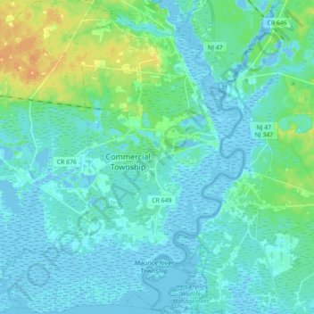
Nombre: Mapa topográfico Commercial Township, altitud, relieve.
Altitud media: 6 m
Altitud mínima: -5 m
Altitud máxima: 29 m
Otros mapas topográficos
Haga clic en un mapa para ver su topografía, su altitud y su relieve.
Maurice River
United States > New Jersey > Cumberland County
Maurice River, Cumberland County, New Jersey, United States
Altitud media: 17 m
Willis Corner
United States > New Jersey > Cumberland County > Stow Creek Township
Willis Corner, Stow Creek Township, Cumberland County, New Jersey, 08323, United States
Altitud media: 11 m
Garton
United States > New Jersey > Cumberland County > Deerfield Township
Garton, Deerfield Township, Cumberland County, New Jersey, 08352, United States
Altitud media: 31 m
Bridgeton
United States > New Jersey > Cumberland County
Bridgeton, Cumberland County, New Jersey, 08302, United States
Altitud media: 18 m
Vineland
United States > New Jersey > Cumberland County > Vineland
Vineland, Cumberland County, New Jersey, United States
Altitud media: 25 m
Greenwich
United States > New Jersey > Cumberland County > Greenwich Township > Greenwich
Greenwich, Greenwich Township, Cumberland County, New Jersey, 08323, United States
Altitud media: 2 m