
Mapa topográfico New Stanton
Mapa interactivo
Haga clic en el mapa para ver la altitud.
Acerca de este mapa
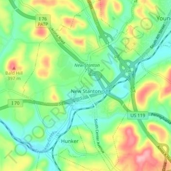
Nombre: Mapa topográfico New Stanton, altitud, relieve.
Altitud media: 325 m
Altitud mínima: 278 m
Altitud máxima: 410 m
Otros mapas topográficos
Haga clic en un mapa para ver su topografía, su altitud y su relieve.
Stanton Heights
United States > Pennsylvania > Westmoreland County > New Stanton > Stanton Heights
Stanton Heights, New Stanton, Westmoreland County, Pennsylvania, 15639, United States
Altitud media: 327 m
Paintersville
United States > Pennsylvania > Westmoreland County > New Stanton > Paintersville
Paintersville, New Stanton, Westmoreland County, Pennsylvania, 15672, United States
Altitud media: 324 m