
Mapa topográfico Anatolia
Mapa interactivo
Haga clic en el mapa para ver la altitud.
Acerca de este mapa
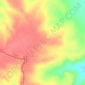
Nombre: Mapa topográfico Anatolia, altitud, relieve.
Altitud media: 952 m
Altitud mínima: 907 m
Altitud máxima: 974 m
Anatolia (Turkish: Anadolu), also known as Asia Minor, is a large peninsula or a region in Turkey, constituting most of its contemporary territory. Geographically, the Anatolian region is bounded by the Mediterranean Sea to the south, the Aegean Sea to the west, the Turkish Straits to the north-west, and the Black Sea to the north. The eastern and southeastern boundary is either the southeastern and eastern borders of Turkey, or an imprecise line from the Gulf of Iskenderun to the Black Sea. Topographically, the Sea of Marmara connects the Black Sea with the Aegean Sea through the Bosporus strait and the Dardanelles strait, and separates Anatolia from Thrace in the Balkan peninsula of Southeastern Europe.
Otros mapas topográficos
Haga clic en un mapa para ver su topografía, su altitud y su relieve.
Karacaahmet
Karacaahmet, Polatlı, Ankara, Central Anatolia Region, Turkey
Altitud media: 683 m
Yassıhüyük
Yassıhüyük, Polatlı, Ankara, Central Anatolia Region, Turkey
Altitud media: 698 m