
Mapa topográfico Belgorod
Mapa interactivo
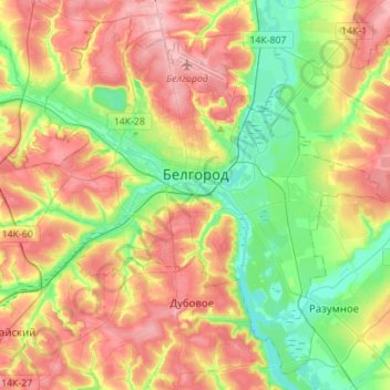
Haga clic en el mapa para ver la altitud.
Acerca de este mapa
Nombre: Mapa topográfico Belgorod, altitud, relieve.
Altitud media: 163 m
Altitud mínima: 107 m
Altitud máxima: 227 m
There were several attacks and incidents reported in Belgorod following the start of the Russian invasion of Ukraine in 2022, during which Belgorod was an important logistics centre for Russian armies. Notably, on 1 April 2022 two Ukrainian Mi-24 performed a night raid and set fire to a fuel depot in Belgorod, in a low-altitude airstrike. On 20 April 2023, a Russian Su-34 fighter jet accidentally dropped a bomb on the city, leaving a crater 20 metres (66 ft) across and injuring two people. On 22 April, more than 3,000 people were evacuated from their homes after an undetonated explosive was found; it was not known if the second bomb had come from the same aircraft.
Otros mapas topográficos
Haga clic en un mapa para ver su topografía, su altitud y su relieve.
Shchetinovka
Russia > Belgorod Oblast > Belgorodsky District
Shchetinovka, Щетиновское сельское поселение, Belgorodsky District, Belgorod Oblast, Central Federal District, Russia
Altitud media: 183 m