
Mapa topográfico Clent
Mapa interactivo
Haga clic en el mapa para ver la altitud.
Acerca de este mapa
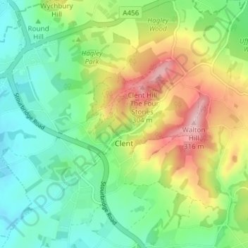
Nombre: Mapa topográfico Clent, altitud, relieve.
Lugar: Clent, Bromsgrove, Worcestershire, England, United Kingdom (52.39945 -2.13824 52.43095 -2.07696)
Altitud media: 183 m
Altitud mínima: 111 m
Altitud máxima: 312 m
Because of the hilly topography of the parish the village consists of several distinct hamlets. These are Upper Clent (Clatterbach and the area around the parish church of St. Leonard), Lower Clent, Holy Cross, Adams Hill and Walton Pool.[2] The Civil Parish of Clent also included part of the village of West Hagley, the population of which is about half that of the whole parish. On the first of April 2016, this part of the parish was transferred to the Parish of Hagley. Though in the ancient ecclesiastical parish of Clent, that area is now part of the Anglican parish of Broome. Part of the parish is an area of agricultural lowland, but to the northwest the ground rises forming the Clent Hills (now owned by the National Trust), which is a popular destination for walkers.
Otros mapas topográficos
Haga clic en un mapa para ver su topografía, su altitud y su relieve.
Major's Green
United Kingdom > England > Worcestershire > Bromsgrove > Wythall CP
Major's Green, Wythall CP, Bromsgrove, Worcestershire, England, B90 1DH, United Kingdom
Altitud media: 146 m
Hunnington CP
United Kingdom > England > Worcestershire > Bromsgrove
Hunnington CP, Bromsgrove, Worcestershire, England, United Kingdom
Altitud media: 165 m
Beacon Wood
United Kingdom > England > Worcestershire > Bromsgrove > Lydiate Ash
Beacon Wood, Lickey and Blackwell CP, Lydiate Ash, Bromsgrove, Worcestershire, England, United Kingdom
Altitud media: 210 m
Tanner's Green
United Kingdom > England > Worcestershire > Bromsgrove > Wythall CP
Tanner's Green, Wythall CP, Bromsgrove, Worcestershire, England, B47 6BE, United Kingdom
Altitud media: 158 m
Finstall CP
United Kingdom > England > Worcestershire > Bromsgrove
Finstall CP, Bromsgrove, Worcestershire, England, United Kingdom
Altitud media: 110 m
Lickey Hills Country Park
United Kingdom > England > Worcestershire > Bromsgrove > Cofton Hackett CP
Lickey Hills Country Park, Cofton Hackett CP, Rubery, Bromsgrove, Worcestershire, England, United Kingdom
Altitud media: 208 m
Clent Hills
United Kingdom > England > Worcestershire > Bromsgrove > Clent
Clent Hills, Clent, Bromsgrove, Worcestershire, England, DY9 9PG, United Kingdom
Altitud media: 210 m
Barnt Green CP
United Kingdom > England > Worcestershire > Bromsgrove
Barnt Green CP, Bromsgrove, Worcestershire, England, United Kingdom
Altitud media: 176 m
Romsley CP
United Kingdom > England > Worcestershire > Bromsgrove
Romsley CP, Bromsgrove, Worcestershire, England, United Kingdom
Altitud media: 205 m
Blackwell
United Kingdom > England > Worcestershire > Bromsgrove > Blackwell
Blackwell, Bromsgrove, Worcestershire, West Midlands, England, B60 1BG, United Kingdom
Altitud media: 162 m
Belbroughton CP
United Kingdom > England > Worcestershire > Bromsgrove
Belbroughton CP, Bromsgrove, Worcestershire, England, United Kingdom
Altitud media: 130 m
Tardebigge
United Kingdom > England > Worcestershire > Bromsgrove
Tardebigge, Bromsgrove, Worcestershire, England, B60 1ND, United Kingdom
Altitud media: 136 m
Hollywood
United Kingdom > England > Worcestershire > Bromsgrove
Hollywood, Bromsgrove, Worcestershire, England, B47 5JN, United Kingdom
Altitud media: 157 m
Bournheath CP
United Kingdom > England > Worcestershire > Bromsgrove > Bournheath CP
Bournheath CP, Bromsgrove, Worcestershire, West Midlands, England, United Kingdom
Altitud media: 147 m
Alvechurch CP
United Kingdom > England > Worcestershire > Bromsgrove
Alvechurch CP, Bromsgrove, Worcestershire, England, United Kingdom
Altitud media: 156 m
Rubery
United Kingdom > England > Worcestershire > Bromsgrove
Rubery, Bromsgrove, Worcestershire, England, B45 9DD, United Kingdom
Altitud media: 213 m
Catshill
United Kingdom > England > Worcestershire > Bromsgrove > Catshill
Catshill, Bromsgrove, Worcestershire, West Midlands, England, B61 0NT, United Kingdom
Altitud media: 151 m
Frankley CP
United Kingdom > England > Worcestershire > Bromsgrove
Frankley CP, Bromsgrove, Worcestershire, England, United Kingdom
Altitud media: 194 m
Lydiate Ash
United Kingdom > England > Worcestershire > Bromsgrove
Lydiate Ash, Bromsgrove, Worcestershire, England, B61 0HU, United Kingdom
Altitud media: 186 m
Gay Hill
United Kingdom > England > Worcestershire > Bromsgrove
Gay Hill, Bromsgrove, Worcestershire, England, B38 0DH, United Kingdom
Altitud media: 176 m
Wythall CP
United Kingdom > England > Worcestershire > Bromsgrove
Wythall CP, Bromsgrove, Worcestershire, England, United Kingdom
Altitud media: 155 m
Cofton Hackett CP
United Kingdom > England > Worcestershire > Bromsgrove
Cofton Hackett CP, Bromsgrove, Worcestershire, England, United Kingdom
Altitud media: 200 m