
Mapa topográfico Woodland Park
Mapa interactivo
Haga clic en el mapa para ver la altitud.
Acerca de este mapa
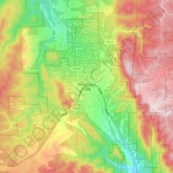
Nombre: Mapa topográfico Woodland Park, altitud, relieve.
Altitud media: 2.657 m
Altitud mínima: 2.419 m
Altitud máxima: 2.884 m
Woodland Park experiences an alpine subarctic climate (Dfc), due to its high elevation and its location in the Rocky Mountains. Summers are warm, but much milder than summers at lower elevations, such as in Colorado Springs, Denver, or the plains to the east. Nights are cool, even chilly in summer.