
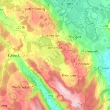
Mapa topográfico Illmensee
Mapa interactivo
Haga clic en el mapa para ver la altitud.
Acerca de este mapa
Nombre: Mapa topográfico Illmensee, altitud, relieve.
Altitud media: 698 m
Altitud mínima: 577 m
Altitud máxima: 839 m
The municipality (Gemeinde) of Illmensee is situated at the southeastern corner of the district of Sigmaringen, in the German state of Baden-Württemberg. Illmensee lies along Sigmaringen's border with the district of Ravensburg to the east and the Bodensee district to the south. The municipality is physically located in a depression formed by the Würm glaciation in the Upper Swabian hill country [de]. The municipality's three lakes, the Illmensee itself, Ruschweiler [de], and the Volzer [de] lakes, are glacial lakes that were also formed by the Würm glaciation. Elevation above sea level in the municipal area ranges from a high of 833 meters (2,733 ft) Normalnull (NN) to a low of 667 meters (2,188 ft) NN.
Otros mapas topográficos
Haga clic en un mapa para ver su topografía, su altitud y su relieve.
Schnerkingen
Germany > Baden-Württemberg > Landkreis Sigmaringen > Meßkirch
Schnerkingen, Meßkirch, Verwaltungsgemeinschaft Meßkirch, Landkreis Sigmaringen, Baden-Württemberg, 88605, Germany
Altitud media: 634 m
Sigmaringen
Germany > Baden-Württemberg > Landkreis Sigmaringen
Sigmaringen, Gemeindeverwaltungsverband Sigmaringen, Landkreis Sigmaringen, Baden-Württemberg, 72488, Germany
Altitud media: 655 m
Pfullendorf
Germany > Baden-Württemberg > Landkreis Sigmaringen
Pfullendorf, Verwaltungsgemeinschaft Pfullendorf, Landkreis Sigmaringen, Baden-Württemberg, 88630, Germany
Altitud media: 654 m