
Mapa topográfico Lake Baringo
Mapa interactivo
Haga clic en el mapa para ver la altitud.
Lake Baringo
Lake Baringo is, after Lake Turkana, the most northern of the Kenyan Rift Valley lakes, with a surface area of 130 square kilometres (50 sq mi) and an elevation of 970 metres (3,180 ft). The lake is fed by several rivers: the Molo, Perkerra and Ol Arabel. It has no obvious outlet; the waters are assumed to seep through lake sediments into the faulted volcanic bedrock. It is one of the two freshwater lakes in the Rift Valley in Kenya, the other being Lake Naivasha.
Acerca de este mapa
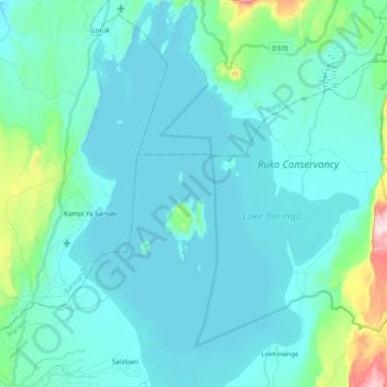
Nombre: Mapa topográfico Lake Baringo, altitud, relieve.
Lugar: Lake Baringo, Marigat, Baringo, Rift Valley, Kenya (0.50837 36.01434 0.72866 36.17328)
Altitud media: 1.053 m
Altitud mínima: 964 m
Altitud máxima: 1.635 m
Otros mapas topográficos
Haga clic en un mapa para ver su topografía, su altitud y su relieve.