
Haz una donación
Mapa topográfico Greenbank
Haga clic en el mapa para ver la altitud.
Haz una donación
Acerca de este mapa
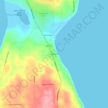
Nombre: Mapa topográfico Greenbank, altitud, relieve.
Lugar: Greenbank, Island County, Washington, 98253, United States (48.07857 -122.59215 48.11857 -122.55215)
Altitud media: 39 m
Altitud mínima: -2 m
Altitud máxima: 136 m
Haz una donación
Otros mapas topográficos
Haga clic en un mapa para ver su topografía, su altitud y su relieve.
Whidbey Island
United States > Washington > Island County
Whidbey Island features a diverse topography characterized by a mix of rolling hills, lush forests, and dramatic coastal cliffs. The island stretches approximately 55 miles in length and up to 12 miles wide, rising to elevations of about 500 feet at its highest point. Its terrain includes expansive farmland…
Altitud media: 45 m
Haz una donación
Whidbey Island
United States > Washington > Island County
Whidbey Island lies partially in the rain shadow of the Olympic Mountain Range to the west, and has a variety of climate zones. This can be observed by rainfall amounts – wettest in the south with average rainfall of 36 inches (910 mm), driest in the central district of Coupeville with average rainfall of 20…
Altitud media: 45 m