
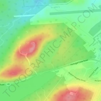
Mapa topográfico Newfound Pond
Mapa interactivo
Haga clic en el mapa para ver la altitud.
Acerca de este mapa
Nombre: Mapa topográfico Newfound Pond, altitud, relieve.
Altitud media: 157 m
Altitud mínima: 112 m
Altitud máxima: 219 m
Otros mapas topográficos
Haga clic en un mapa para ver su topografía, su altitud y su relieve.
Cape Spear
Canada > Newfoundland and Labrador > St. John's
Cape Spear, St. John's, Newfoundland, Newfoundland and Labrador, Canada
Altitud media: 7 m
Cape Bay
Canada > Newfoundland and Labrador > St. John's
Cape Bay, St. John's, Newfoundland, Newfoundland and Labrador, Canada
Altitud media: 21 m
Wigmore
Canada > Newfoundland and Labrador > St. John's
Wigmore, St. John's, Newfoundland, Newfoundland and Labrador, Canada
Altitud media: 118 m
Signal Hill National Historic Site
Canada > Newfoundland and Labrador > St. John's
Signal Hill National Historic Site, 230, Quidi Vidi, Churchill Park, St. John's, Newfoundland and Labrador, Canada
Altitud media: 29 m
Blackhead
Canada > Newfoundland and Labrador > St. John's > Blackhead
Blackhead, St. John's, Newfoundland and Labrador, Canada
Altitud media: 48 m