
Mapa topográfico Hunter
Mapa interactivo
Haga clic en el mapa para ver la altitud.
Acerca de este mapa
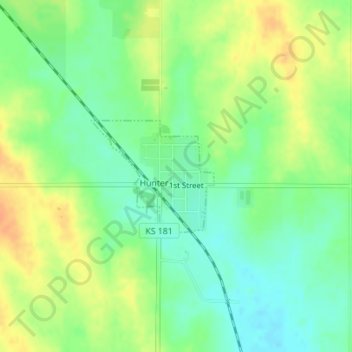
Nombre: Mapa topográfico Hunter, altitud, relieve.
Lugar: Hunter, Mitchell County, Kansas, United States (39.23037 -98.40350 39.23897 -98.39133)
Altitud media: 495 m
Altitud mínima: 478 m
Altitud máxima: 515 m
Otros mapas topográficos
Haga clic en un mapa para ver su topografía, su altitud y su relieve.
Asherville
United States > Kansas > Mitchell County
Asherville, Mitchell County, Kansas, 67478, United States
Altitud media: 412 m
Victor
United States > Kansas > Mitchell County
Victor, Mitchell County, Kansas, United States
Altitud media: 460 m
Simpson
United States > Kansas > Mitchell County
Simpson, Mitchell County, Kansas, 67478, United States
Altitud media: 407 m
Beloit
United States > Kansas > Mitchell County
Beloit, Mitchell County, Kansas, United States
Altitud media: 432 m
Glen Elder
United States > Kansas > Mitchell County
Glen Elder, Mitchell County, Kansas, 67446, United States
Altitud media: 441 m