
Mapa topográfico Horanadu
Mapa interactivo
Haga clic en el mapa para ver la altitud.
Acerca de este mapa
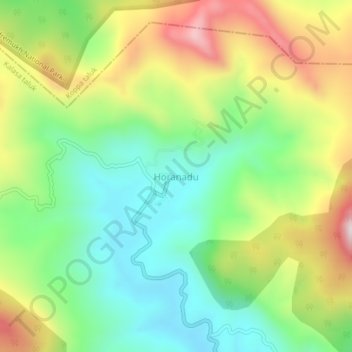
Nombre: Mapa topográfico Horanadu, altitud, relieve.
Altitud media: 1.022 m
Altitud mínima: 761 m
Altitud máxima: 1.430 m
Hornadu, also known as Horanadu, is a Hindu holy locale and also a jain holy center Panchayat village located in kalasa taluk of Chikkamagaluru district, Karnataka, India. The deity at the Annapoorneshwari Temple at Hornadu is Annapurneshwari. The main deity of the goddess was put in place by Adi Shankaracharya; the new deity of goddess Annapurneshwari was consecrated in the temple in 1973. Horanadu has an elevation of 831 m (2,726 ft)
Otros mapas topográficos
Haga clic en un mapa para ver su topografía, su altitud y su relieve.
Kudremukha
India > Karnataka > Kalasa taluk
Kudremukha, Kalasa taluk, Chikkamagaluru District, Karnataka, India
Altitud media: 858 m
Kalasa
India > Karnataka > Kalasa taluk
Kalasa, Kalasa taluk, Chikkamagaluru District, Karnataka, 577124, India
Altitud media: 897 m