
Gracias por apoyar a este sitio ❤️
Haz una donación
Haz una donación
Mapa topográfico Mattighofen
Haga clic en el mapa para ver la altitud.
Gracias por apoyar a este sitio ❤️
Haz una donación
Haz una donación
Mattighofen
Mattighofen liegt auf 454 m Höhe im Innviertel. Die Ausdehnung beträgt von Nord nach Süd 3 km, von West nach Ost 3,3 km. Die Gesamtfläche beträgt 5,2 km². 13,5 % der Fläche sind bewaldet, 50,0 % der Fläche sind landwirtschaftlich genutzt.
Gracias por apoyar a este sitio ❤️
Haz una donación
Haz una donación
Acerca de este mapa
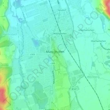
Nombre: Mapa topográfico Mattighofen, altitud, relieve.
Altitud media: 451 m
Altitud mínima: 430 m
Altitud máxima: 533 m
Gracias por apoyar a este sitio ❤️
Haz una donación
Haz una donación
Otros mapas topográficos
Haga clic en un mapa para ver su topografía, su altitud y su relieve.
Lohnsberg
Österreich > Oberösterreich > Bezirk Braunau am Inn > Gilgenberg am Weilhart > Lohnsberg
Altitud media: 480 m
Gracias por apoyar a este sitio ❤️
Haz una donación
Haz una donación