
Mapa topográfico Cedar Island
Mapa interactivo
Haga clic en el mapa para ver la altitud.
Acerca de este mapa
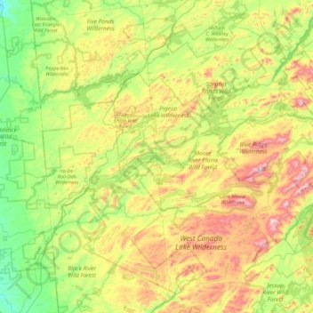
Nombre: Mapa topográfico Cedar Island, altitud, relieve.
Altitud media: 589 m
Altitud mínima: 303 m
Altitud máxima: 1.158 m
Otros mapas topográficos
Haga clic en un mapa para ver su topografía, su altitud y su relieve.
Brown Tract Pond Campground
United States > New York > Hamilton County > Town of Inlet
Brown Tract Pond Campground, Town of Inlet, Hamilton County, New York, United States
Altitud media: 564 m