
Mapa topográfico Pico de Mulhacén
Mapa interactivo
Haga clic en el mapa para ver la altitud.
Acerca de este mapa
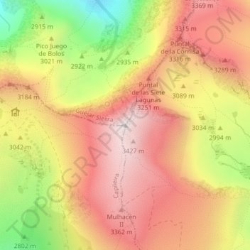
Nombre: Mapa topográfico Pico de Mulhacén, altitud, relieve.
Altitud media: 3.070 m
Altitud mínima: 2.489 m
Altitud máxima: 3.473 m
Mulhacén ([mulaˈθen]), with an elevation of 3,482 metres (11,424 ft), is the highest mountain in peninsular Spain and in all of the Iberian Peninsula. It is part of the Sierra Nevada range in the Penibaetic System. It is named after Abu'l-Hasan Ali, known as Muley Hacén in Spanish, the penultimate Muslim ruler of Granada in the 15th century who, according to legend, was buried on the summit of the mountain.