
Mapa topográfico Laage
Mapa interactivo
Haga clic en el mapa para ver la altitud.
Acerca de este mapa
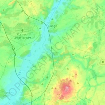
Nombre: Mapa topográfico Laage, altitud, relieve.
Altitud media: 39 m
Altitud mínima: 8 m
Altitud máxima: 127 m
To the west and east of the Recknitz-Urstromtal there are terminal moraines. Der Kalte Berg is 62m above the Normalhöhennull, the tallest point of elevation in the municipal area. Rostock Laage Airport is located a few kilometers west of Laage.
Otros mapas topográficos
Haga clic en un mapa para ver su topografía, su altitud y su relieve.
Sanitz
Germany > Mecklenburg-Vorpommern > Landkreis Rostock > Sanitz
Sanitz, Landkreis Rostock, Mecklenburg-Vorpommern, 18190, Germany
Altitud media: 40 m
Altkalen
Germany > Mecklenburg-Vorpommern > Landkreis Rostock > Altkalen
Altkalen, Gnoien, Landkreis Rostock, Mecklenburg-Vorpommern, Germany
Altitud media: 34 m
Cammin
Germany > Mecklenburg-Vorpommern > Landkreis Rostock
Cammin, Tessin, Landkreis Rostock, Mecklenburg-Vorpommern, Germany
Altitud media: 36 m
Teterow
Germany > Mecklenburg-Vorpommern > Landkreis Rostock
Teterow, Landkreis Rostock, Mecklenburg-Vorpommern, 17166, Germany
Altitud media: 39 m
Laage
Germany > Mecklenburg-Vorpommern > Landkreis Rostock > Laage
Laage, Landkreis Rostock, Mecklenburg-Vorpommern, 18299, Germany
Altitud media: 37 m