
Haz una donación
Mapa topográfico Leme
Haga clic en el mapa para ver la altitud.
Haz una donación
Leme
Its average altitude is 619 meters above sea level (2030.8 ft). The relief is lightly wavy in the urban area and in most of rural area, which makes the urban expansion and the agricultural cultivation easier, as well as the transport by bicycle (cheap and non-polluting). This kind of transport is very common in Leme.
Haz una donación
Acerca de este mapa
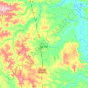
Nombre: Mapa topográfico Leme, altitud, relieve.
Altitud media: 652 m
Altitud mínima: 559 m
Altitud máxima: 834 m
Haz una donación
Otros mapas topográficos
Haga clic en un mapa para ver su topografía, su altitud y su relieve.
Kobayat Líbano
Brazil > São Paulo > Região Metropolitana de Piracicaba > Piracicaba
Altitud media: 521 m
Nova Piracicaba
Brazil > São Paulo > Região Metropolitana de Piracicaba > Piracicaba
Altitud media: 493 m
Mirante Rio Piracicaba
Brazil > São Paulo > Região Metropolitana de Piracicaba > Piracicaba
Altitud media: 505 m