
Mapa topográfico Sensweiler
Mapa interactivo
Haga clic en el mapa para ver la altitud.
Acerca de este mapa
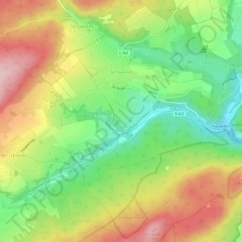
Nombre: Mapa topográfico Sensweiler, altitud, relieve.
Altitud media: 524 m
Altitud mínima: 409 m
Altitud máxima: 660 m
Otros mapas topográficos
Haga clic en un mapa para ver su topografía, su altitud y su relieve.
Baumholder
Duitsland > Rijnland-Palts > Landkreis Birkenfeld
Baumholder, Landkreis Birkenfeld, Rijnland-Palts, 55774, Duitsland
Altitud media: 451 m
Eckersweiler
Duitsland > Rijnland-Palts > Landkreis Birkenfeld
Eckersweiler, Baumholder, Landkreis Birkenfeld, Rijnland-Palts, Duitsland
Altitud media: 519 m
Allenbach
Duitsland > Rijnland-Palts > Landkreis Birkenfeld > Allenbach
Allenbach, Herrstein-Rhaunen, Landkreis Birkenfeld, Rijnland-Palts, Duitsland
Altitud media: 566 m
Hattgenstein
Duitsland > Rijnland-Palts > Landkreis Birkenfeld > Hattgenstein
Hattgenstein, Birkenfeld, Landkreis Birkenfeld, Rijnland-Palts, Duitsland
Altitud media: 552 m
Heimbach
Duitsland > Rijnland-Palts > Landkreis Birkenfeld
Heimbach, Baumholder, Landkreis Birkenfeld, Rijnland-Palts, Duitsland
Altitud media: 412 m
Huben
Duitsland > Rijnland-Palts > Landkreis Birkenfeld > Hintertiefenbach
Huben, Hintertiefenbach, Herrstein-Rhaunen, Landkreis Birkenfeld, Rijnland-Palts, 55743, Duitsland
Altitud media: 422 m