
Mapa topográfico Isernia
Mapa interactivo
Haga clic en el mapa para ver la altitud.
Acerca de este mapa
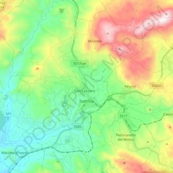
Nombre: Mapa topográfico Isernia, altitud, relieve.
Lugar: Isernia, Molise, 86170, Italy (41.54653 14.16157 41.67572 14.27703)
Altitud media: 633 m
Altitud mínima: 252 m
Altitud máxima: 1.385 m
The commune of Isernia includes 16 frazioni. The most densely populated is Castelromano which is positioned in a plain at the base of the La Romana mount, elevation 862 metres (2,828 ft), 5 kilometres (3 mi) from Isernia.