
Mapa topográfico Plain
Haga clic en el mapa para ver la altitud.
Acerca de este mapa
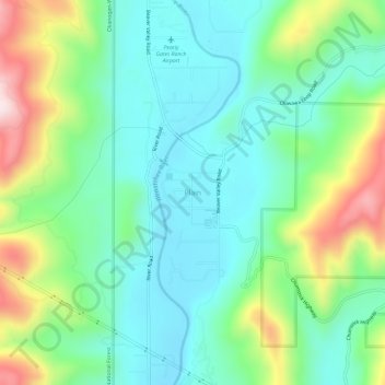
Nombre: Mapa topográfico Plain, altitud, relieve.
Lugar: Plain, Chelan County, Washington, United States (47.74086 -120.68120 47.78086 -120.64120)
Altitud media: 673 m
Altitud mínima: 546 m
Altitud máxima: 978 m
Otros mapas topográficos
Haga clic en un mapa para ver su topografía, su altitud y su relieve.
Wenatchee
United States > Washington > Chelan County
Wenatchee is characterized by its diverse topography, nestled at an average elevation of approximately 800 feet. The city is situated in a valley surrounded by significant geographical features, including the rugged foothills of the Cascade Mountains, which rise sharply to elevations of over 4,500 feet just to…
Altitud media: 302 m
Leavenworth
United States > Washington > Chelan County
Leavenworth, Washington, is nestled at approximately 1,171 feet (357 meters) above sea level in the eastern foothills of the Cascade Mountains. The town is surrounded by rugged terrain, with steep slopes that rise sharply to elevations exceeding 5,000 feet (1,524 meters), and prominent peaks such as Icicle…
Altitud media: 418 m
Leavenworth
United States > Washington > Chelan County
Leavenworth is situated in the Cascade Mountains at an elevation of 1,168 feet (356 m) above sea level and is surrounded by mountains that range from 5,000 to 8,000 feet (1,500 to 2,400 m) in height. The city lies along the Wenatchee River near its confluence with Icicle Creek. According to the United States…
Altitud media: 418 m