
Mapa topográfico Eldoret
Mapa interactivo
Haga clic en el mapa para ver la altitud.
Eldoret
Eldoret is a principal town in the Rift Valley region of Kenya and serves as the capital of Uasin Gishu County. The town was referred to by white settlers as Farm 64, 64 and colloquially by locals as 'Sisibo'. As per the 2019 Kenya Population and Housing Census, Eldoret is the fifth most populated urban area in the country after Kenya's 4 cities of Nairobi, Mombasa, Kisumu and Nakuru. Lying south of the Cherangani Hills, the local elevation varies from about 2,100 metres (6,900 ft) at the airport to more than 2,700 metres (8,900 ft) in nearby areas. The population was 289,380 in the 2009 Census, and it is currently the fastest growing town in Kenya with 475,716 people according to 2019 National Census. Eldoret was on course to be named Kenya's fourth city, but was edged out by Nakuru in 2021.
Acerca de este mapa
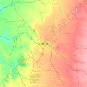
Nombre: Mapa topográfico Eldoret, altitud, relieve.
Altitud media: 2.093 m
Altitud mínima: 1.829 m
Altitud máxima: 2.385 m