
Mapa topográfico Bergheim
Mapa interactivo
Haga clic en el mapa para ver la altitud.
Acerca de este mapa
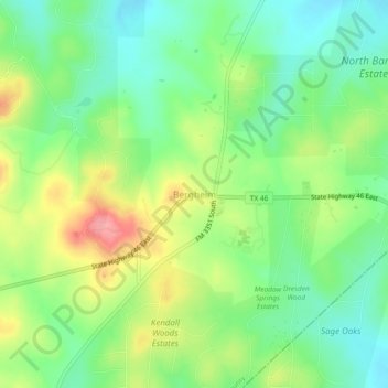
Nombre: Mapa topográfico Bergheim, altitud, relieve.
Lugar: Bergheim, Kendall County, Texas, 78004, United States (29.80744 -98.59530 29.84744 -98.55530)
Altitud media: 419 m
Altitud mínima: 380 m
Altitud máxima: 481 m
Bergheim is an unincorporated community in eastern Kendall County, Texas, United States known for its German-Texan culture and heritage. It lies along State Highway 46 east of the city of Boerne, the county seat of Kendall County. Its elevation is 1,437 feet (438 m). Although Bergheim is unincorporated, it has a post office, with the ZIP code of 78004; the ZCTA for ZIP Code 78004, consisting mostly of rural land, had a population of 1,183 at the 2010 census. The community is part of the San Antonio metropolitan statistical area. Bergheim is still a predominantly a ranching and agricultural community.
Otros mapas topográficos
Haga clic en un mapa para ver su topografía, su altitud y su relieve.
Boerne
United States > Texas > Kendall County
Boerne, Kendall County, Texas, United States
Altitud media: 465 m
Walnut Grove
United States > Texas > Kendall County
Walnut Grove, Kendall County, Texas, United States
Altitud media: 455 m
Kreutzberg
United States > Texas > Kendall County
Kreutzberg, Kendall County, Texas, United States
Altitud media: 426 m
Boerne
United States > Texas > Kendall County
Boerne, Kendall County, Texas, United States
Altitud media: 465 m
Waring
United States > Texas > Kendall County
Waring, Kendall County, Texas, 78074, United States
Altitud media: 425 m
Comfort
United States > Texas > Kendall County
Comfort, Kendall County, Texas, 70813, United States
Altitud media: 457 m
Nelson City
United States > Texas > Kendall County
Nelson City, Kendall County, Texas, United States
Altitud media: 485 m