
Mapa topográfico Upper Canard
Mapa interactivo
Haga clic en el mapa para ver la altitud.
Acerca de este mapa
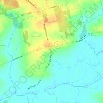
Nombre: Mapa topográfico Upper Canard, altitud, relieve.
Altitud media: 13 m
Altitud mínima: 1 m
Altitud máxima: 35 m
Otros mapas topográficos
Haga clic en un mapa para ver su topografía, su altitud y su relieve.
Armstrong Lake
Canada > Nova Scotia > Municipality of the County of Kings
Armstrong Lake, Municipality of the County of Kings, Kings County, Nova Scotia, Canada
Altitud media: 208 m
Upper Dyke
Canada > Nova Scotia > Municipality of the County of Kings
Upper Dyke, Municipality of the County of Kings, Kings County, Nova Scotia, Canada
Altitud media: 18 m
Annapolis Valley
Canada > Nova Scotia > Municipality of the County of Kings > Auburn
Annapolis Valley, Auburn, Municipality of the County of Kings, Kings County, Nova Scotia, B0P 1R0, Canada
Altitud media: 77 m
Brow of the Mountain
Canada > Nova Scotia > Municipality of the County of Kings
Brow of the Mountain, Municipality of the County of Kings, Kings County, Nova Scotia, Canada
Altitud media: 136 m
Black River Lake
Canada > Nova Scotia > Municipality of the County of Kings
Black River Lake, Municipality of the County of Kings, Kings County, Nova Scotia, Canada
Altitud media: 188 m
Frog Lake
Canada > Nova Scotia > Municipality of the County of Kings
Frog Lake, Municipality of the County of Kings, Kings County, Nova Scotia, Canada
Altitud media: 211 m
Tremont
Canada > Nova Scotia > Municipality of the County of Kings
Tremont, Municipality of the County of Kings, Kings County, Nova Scotia, B0P 1R0, Canada
Altitud media: 58 m
Hardwood Lake
Canada > Nova Scotia > Municipality of the County of Kings
Hardwood Lake, Municipality of the County of Kings, Kings County, Nova Scotia, Canada
Altitud media: 218 m
Welsford
Canada > Nova Scotia > Municipality of the County of Kings
Welsford, Municipality of the County of Kings, Kings County, Nova Scotia, B0P 1E0, Canada
Altitud media: 129 m
Newtonville
Canada > Nova Scotia > Municipality of the County of Kings
Newtonville, Municipality of the County of Kings, Kings County, Nova Scotia, B4P 2R1, Canada
Altitud media: 158 m
North Kentville
Canada > Nova Scotia > Municipality of the County of Kings
North Kentville, Municipality of the County of Kings, Kings County, Nova Scotia, Canada
Altitud media: 29 m
Cape Split
Canada > Nova Scotia > Municipality of the County of Kings > Scots Bay
Cape Split, Scots Bay, Municipality of the County of Kings, Kings County, Nova Scotia, Canada
Altitud media: 6 m
Morristown
Canada > Nova Scotia > Municipality of the County of Kings
Morristown, Municipality of the County of Kings, Kings County, Nova Scotia, B0P 1E0, Canada
Altitud media: 167 m
Harbourville
Canada > Nova Scotia > Municipality of the County of Kings
Harbourville, Municipality of the County of Kings, Kings County, Nova Scotia, Canada
Altitud media: 86 m
Tomahawk Lake
Canada > Nova Scotia > Municipality of the County of Kings
Tomahawk Lake, Municipality of the County of Kings, Kings County, Nova Scotia, Canada
Altitud media: 222 m
Gaspereau Mountain
Canada > Nova Scotia > Municipality of the County of Kings > Forest Hill
Gaspereau Mountain, Forest Hill, Municipality of the County of Kings, Kings County, Nova Scotia, B4P 2R1, Canada
Altitud media: 185 m
Dalhousie Road
Canada > Nova Scotia > Municipality of the County of Kings
Dalhousie Road, East Dalhousie, Municipality of the County of Kings, Kings County, Nova Scotia, B0R 1H0, Canada
Altitud media: 207 m
Blue Mountain
Canada > Nova Scotia > Municipality of the County of Kings
Blue Mountain, Municipality of the County of Kings, Kings County, Nova Scotia, B4N 3V8, Canada
Altitud media: 224 m
Murphy Lake
Canada > Nova Scotia > Municipality of the County of Kings
Murphy Lake, Municipality of the County of Kings, Kings County, Nova Scotia, B4N 3V8, Canada
Altitud media: 211 m
Greenwich
Canada > Nova Scotia > Municipality of the County of Kings
Greenwich, Municipality of the County of Kings, Kings County, Nova Scotia, B4P 0B2, Canada
Altitud media: 32 m
Black River
Canada > Nova Scotia > Municipality of the County of Kings > Black River
Black River, Municipality of the County of Kings, Kings County, Nova Scotia, Canada
Altitud media: 195 m
New Minas
Canada > Nova Scotia > Municipality of the County of Kings
New Minas, Municipality of the County of Kings, Kings County, Nova Scotia, Canada
Altitud media: 63 m
Lumsden Dam
Canada > Nova Scotia > Municipality of the County of Kings
Lumsden Dam, Municipality of the County of Kings, Kings County, Nova Scotia, Canada
Altitud media: 182 m
Canning
Canada > Nova Scotia > Municipality of the County of Kings
Canning, Municipality of the County of Kings, Kings County, Nova Scotia, B0P 1H0, Canada
Altitud media: 22 m
Blomidon
Canada > Nova Scotia > Municipality of the County of Kings
Blomidon, Municipality of the County of Kings, Kings County, Nova Scotia, B0P 1T0, Canada
Altitud media: 56 m
Avonport
Canada > Nova Scotia > Municipality of the County of Kings
Avonport, Municipality of the County of Kings, Kings County, Nova Scotia, B0P 1B0, Canada
Altitud media: 26 m
Gaspereau
Canada > Nova Scotia > Municipality of the County of Kings > Gaspereau
Gaspereau, Municipality of the County of Kings, Kings County, Nova Scotia, B4P 2R1, Canada
Altitud media: 95 m
Port Williams
Canada > Nova Scotia > Municipality of the County of Kings
Port Williams, Municipality of the County of Kings, Kings County, Nova Scotia, Canada
Altitud media: 24 m
Aylesford
Canada > Nova Scotia > Municipality of the County of Kings
Aylesford, Municipality of the County of Kings, Kings County, Nova Scotia, B0P 1C0, Canada
Altitud media: 30 m
Hants Border
Canada > Nova Scotia > Municipality of the County of Kings
Hants Border, Municipality of the County of Kings, Kings County, Nova Scotia, B0P 1P0, Canada
Altitud media: 58 m
Davison Street
Canada > Nova Scotia > Municipality of the County of Kings > Forest Hill
Davison Street, Forest Hill, Municipality of the County of Kings, Kings County, Nova Scotia, B4P 2R1, Canada
Altitud media: 195 m
Wallbrook
Canada > Nova Scotia > Municipality of the County of Kings
Wallbrook, Municipality of the County of Kings, Kings County, Nova Scotia, B4P 2R3, Canada
Altitud media: 104 m
Robinson Corner
Canada > Nova Scotia > Municipality of the County of Kings
Robinson Corner, Municipality of the County of Kings, Kings County, Nova Scotia, B4P 2R3, Canada
Altitud media: 174 m
Coldbrook
Canada > Nova Scotia > Municipality of the County of Kings
Coldbrook, Municipality of the County of Kings, Kings County, Nova Scotia, Canada
Altitud media: 79 m