
Mapa topográfico Trail
Mapa interactivo
Haga clic en el mapa para ver la altitud.
Acerca de este mapa
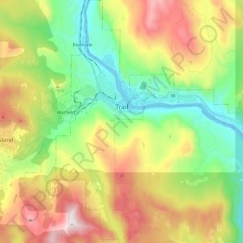
Nombre: Mapa topográfico Trail, altitud, relieve.
Altitud media: 888 m
Altitud mínima: 395 m
Altitud máxima: 1.637 m
Summer climate in Trail is generally hot and dry with moderately cool nights. Temperatures often exceed 35 °C (95 °F) during summer afternoons, average 29 °C (84 °F). Thunderstorms are common during the late-Spring and Summer season, often moving into the valley from the south. The fall months bring dense river fog, especially overnight and in the morning, as a cold air inversion lingers above the relatively warm river surface. Winters are mild to cold with periods of moderate snowfall. Nearby villages such as Warfield, Fruitvale and especially Rossland receive greater amounts of snow due to higher elevation.
Otros mapas topográficos
Haga clic en un mapa para ver su topografía, su altitud y su relieve.
Stump Lake
Canada > British Columbia > Regional District of Kootenay Boundary > Area E (Beaverdell/West Boundary)
Stump Lake, Area E (Beaverdell/West Boundary), Regional District of Kootenay Boundary, British Columbia, Canada
Altitud media: 1.321 m
Grand Forks
Canada > British Columbia > Regional District of Kootenay Boundary
Grand Forks, Regional District of Kootenay Boundary, British Columbia, Canada
Altitud media: 586 m
Rossland
Canada > British Columbia > Regional District of Kootenay Boundary
Rossland, Regional District of Kootenay Boundary, British Columbia, V0G 1Y0, Canada
Altitud media: 1.128 m
Regional District of Kootenay Boundary
Canada > British Columbia > Regional District of Kootenay Boundary
Regional District of Kootenay Boundary, British Columbia, Canada
Altitud media: 1.215 m