
Mapa topográfico Kapuskasing
Mapa interactivo
Haga clic en el mapa para ver la altitud.
Acerca de este mapa
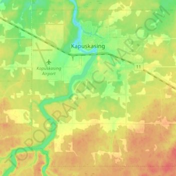
Nombre: Mapa topográfico Kapuskasing, altitud, relieve.
Altitud media: 227 m
Altitud mínima: 202 m
Altitud máxima: 249 m
Kapuskasing lies in the heart of the Great Clay Belt. The topography of the region is very flat, dotted with numerous small lakes and muskeg bogs. Also in the heart of Canada's boreal forest, the region is drained by rivers running north to James Bay. The district is heavily forested, mostly by thick stands of black spruce that have commercial value as pulpwood.
Otros mapas topográficos
Haga clic en un mapa para ver su topografía, su altitud y su relieve.
Moosonee
Canada > Ontario > Cochrane District
Moosonee, Cochrane District, Northeastern Ontario, Ontario, P0L 1Y0, Canada
Altitud media: 13 m
Heart Lake
Canada > Ontario > Cochrane District > Timmins
Heart Lake, Timmins, Cochrane District, Northeastern Ontario, Ontario, Canada
Altitud media: 294 m
Shallow River
Canada > Ontario > Cochrane District > Iroquois Falls
Shallow River, Iroquois Falls, Cochrane District, Northeastern Ontario, Ontario, Canada
Altitud media: 272 m
Wavell
Canada > Ontario > Cochrane District > Black River-Matheson Township
Wavell, Black River-Matheson Township, Cochrane District, Northeastern Ontario, Ontario, Canada
Altitud media: 304 m
Schumacher
Canada > Ontario > Cochrane District > Timmins
Schumacher, Timmins, Cochrane District, Northeastern Ontario, Ontario, P0N 1G0, Canada
Altitud media: 306 m
Ramore
Canada > Ontario > Cochrane District
Ramore, Black River-Matheson Township, Cochrane District, Northeastern Ontario, Ontario, Canada
Altitud media: 289 m
Timmins
Canada > Ontario > Cochrane District
Timmins, Cochrane District, Northeastern Ontario, Ontario, Canada
Altitud media: 302 m