
Haz una donación
Mapa topográfico Puyallup
Haga clic en el mapa para ver la altitud.
Haz una donación
Puyallup
Downtown Puyallup and nearby neighborhoods lie within the hazard zone for lahars that could be produced in a moderate or large eruption of nearby Mount Rainier. The city's position on the Puyallup River is downstream of the western flank of Mount Rainier, which has the highest potential for producing far-traveled lahars due to the abundance of weakened clay-rich rock at high altitudes. The entire Puyallup Valley is built on deposits of the 5,600-year-old Osceola Mudflow, which deposited as much as 98 feet (30 m) of material and was similar to largest lahars Mount Rainier could produce. A 2009 study by the United States Geological Survey (USGS) determined that Puyallup has the highest number of dependent-population facilities, public venues, and overall community assets within lahar hazard zones. The Washington State Department of Natural Resources estimates that the Puyallup Valley could experience $6–12 billion in damage from a major lahar.
Haz una donación
Acerca de este mapa
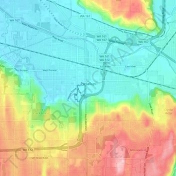
Nombre: Mapa topográfico Puyallup, altitud, relieve.
Lugar: Puyallup, Pierce County, Washington, United States (47.14731 -122.33789 47.21849 -122.23481)
Altitud media: 67 m
Altitud mínima: 4 m
Altitud máxima: 185 m
Haz una donación
Otros mapas topográficos
Haga clic en un mapa para ver su topografía, su altitud y su relieve.
Mount Rainier
United States > Washington > Pierce County
Mount Rainier (/reɪˈnɪər/), indigenously known as Tahoma, Tacoma, Tacobet, or təqʷubəʔ, is a large active stratovolcano in the Cascade Range of the Pacific Northwest, located in Mount Rainier National Park about 59 miles (95 km) south-southeast of Seattle. With a summit elevation of 14,411 ft (4,392…
Altitud media: 3.911 m
Haz una donación
Haz una donación
Mount Rainier
United States > Washington > Pierce County
Mount Rainier (/reɪˈnɪər/ ray-NEER), also known as Tahoma, is a large active stratovolcano in the Cascade Range of the Pacific Northwest in the United States. The mountain is located in Mount Rainier National Park about 59 miles (95 km) south-southeast of Seattle. With a summit elevation of 14,411 ft…
Altitud media: 3.911 m
Mount Rainier
United States > Washington > Pierce County
Mount Rainier (/reɪˈnɪər/ ray-NEER), also known as Tahoma, is a large active stratovolcano in the Cascade Range of the Pacific Northwest in the United States. The mountain is located in Mount Rainier National Park about 59 miles (95 km) south-southeast of Seattle. With an officially recognized summit…
Altitud media: 3.911 m
Haz una donación
Mount Rainier
United States > Washington > Pierce County
Mount Rainier (/reɪˈnɪər/ ray-NEER), also known as Tahoma, is a large active stratovolcano in the Cascade Range of the Pacific Northwest in the United States. The mountain is located in Mount Rainier National Park about 59 miles (95 km) south-southeast of Seattle. With an officially recognized summit…
Altitud media: 3.911 m
Haz una donación
Haz una donación
Haz una donación
Haz una donación
Haz una donación